So you’ve made it to Westport, but you’d like to get a bird’s eye view of the truly extraordinary landscape in which it sits. We don’t blame you. If you’re dying to get into your hiking boots and take to the hills, take a peek at these peaks; they’re sure to pique your interest… (sorry!). We’ll start with the smallest of our five mountains, and work our way – huffing and puffing – all the way to the highest.
Five Peaks To Climb Near Westport
1. DIAMOND HILL
Less than an hour’s drive down the road from Westport, Diamond Hill rises resplendent above the village of Letterfrack. At 445 metres, this ain’t no small hill, but for a hike with a view, it really is a diamond! Just over the county border with Galway, Diamond Hill is located in Connemara National Park, and the park’s visitor centre is the perfect place to start this 7km walk. The trail’s solid surface is generally easy enough to walk on, with rocky paths, stone steps, and timber boardwalks that cross boggy sections.
The summit ridge is a narrow fin of glinting quartzite (quite possibly where the mountain’s name originates). This ridge is about half a kilometre long, culminating in a cairn that marks summit.
Your efforts to get to the top will be handsomely rewarded. A slow 360-degree spin will take in views of Inishturk, Inishbofin and Inishshark islands, Tully Mountain rising over Ballynakill Harbour, the serpentine Wild Atlantic coastline, the iconic peaks of the Twelve Bens, the summit of Mweelrea, and Kylemore Abbey beckoning regally from neighbouring Kylemore Lough. Don’t get dizzy now!
The loop descends the back of the mountain, eventually rejoining the path to the visitor centre.
THE BASICS
Terrain: Rocky paths, stone steps, and timber boardwalks
Starting Point: Connemara National Park Visitor Centre
Length: 7km
Estimated time: 2hrs
Difficulty: Moderate
2. CROAGHAUN
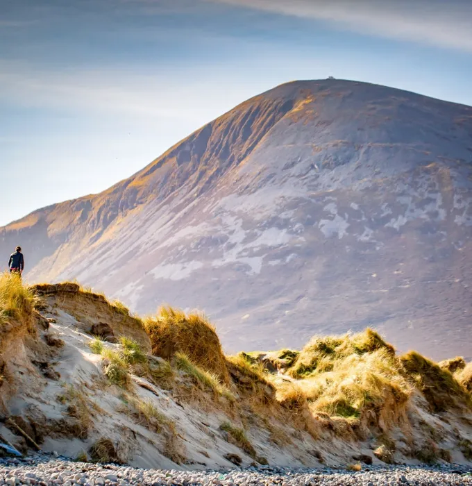
At 688 metres, Croaghaun (or Croaghan) is Achill Island’s highest and most westerly peak. Its northern slopes boast the highest sea cliffs in Ireland – and the third-highest sea cliffs in Europe. As if that were not enough, the mountain is also home to Ireland’s highest corrie (glacial) lake.
Croaghaun rises at one of Ireland’s most westerly points, and when you get to the top of it you will really feel like you have a god’s eye view of the edge of the world. It also looks down on the beautiful crescent-shaped beach of Keem Bay, a favourite hang-out for basking sharks, which can be seen regularly as they cruise the shallows to feed on plankton.
To get to the starting point for a hike to the top, take the scenic drive or cycle to the Keem Bay car park at the foot of Croaghaun and climb straight up (and up!) to the summit. The hike is very steep in parts, especially towards the end. Keep an eye out for the resident peregrine falcons on the way!
THE BASICS
Starting point: Keem Bay car park
Terrain: Boggy/grassy hillside, sometimes extremely steep
Estimated time: 5hrs
Difficulty: Hard
3. CROAGH PATRICK
And now we get to Mayo’s third highest peak – that mountain most associated with Westport, Croagh Patrick (or the Reek as it is known locally).
Situated just 8 kilometres from Westport town, the mountain’s familiar pyramidal cone soars 764 metres above the villages of Murrisk and Lecanvey and the surrounding countryside.
Follow the pilgrim path from Murrisk up to the top and drink in the jaw-dropping views of Clew Bay, with its myriad hues of blue and its hundreds of islands, all shapes and sizes. Even if you don’t make it to the top (the final part of the climb is particularly challenging), the views on the way up are truly stunning – though only those who do reach the peak will get to marvel at the pretty little chapel at the top. Built in 1905 by 12 local men, using local stone and cement that was hauled up the mountain’s steep sides by donkey, it stands as a testament to determination, perseverance and faith.
A word of warning: All year round, Mayo Mountain Rescue is kept busy rescuing walkers from the Reek. While the mountain is world famous and a popular challenge, it is not to be taken lightly. The weather can close in quickly, and slips and falls are frequent. Please wear sensible clothing and appropriate footwear.
THE BASICS
Terrain: Rough, rocky path and shale, with some steep climbs, especially at the shale-covered top cone
Starting Point: Murrisk Car Park/Visitor Centre
Length (Kms): 7km
Estimated time: 3.5hrs
Difficulty: Moderate to strenuous
4. NEPHIN
Less than a 45-minute drive northeast from Westport, Nephin rises to a heart-busting 806m. This is the second-highest mountain in County Mayo, and the views from the cairn that marks its summit are breathtaking.
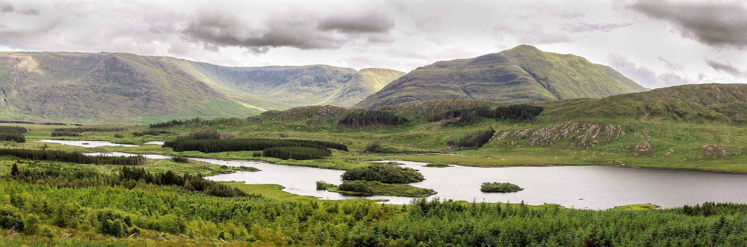
Nephin is not part of the Nephin Beg Range, which lies to its west. Rather, it stands alone, its gentle-giant form dominating the surrounding landscape, with Lough Conn to its east, the Windy Gap/Barnageehy Mountain Pass to the south, Birreencorragh and Knockaffertagh mountains to the west and Clew Bay to the southwest. On a clear day, it’s possible to see as far as the mountains of Donegal to northeast and Connemara to the south.
To climb Nephin, first decide on a route – there are several to chose from. To get to the starting point on Nephin’s southern side, take the N5 towards Castlebar, turning off at Islandeady to meet up with the R312. After the road passes beautiful Beltra lake, it continues alongside Crumpaun River. Park off-road at the entrance to the nearby forest at Pruglish (grid ref G084 047), follow the forest path northwest from there, and soon Nephin’s magnificent slopes will come into view.
THE BASICS
Starting point: Pruglish Forest
Terrain: Heather, grass, giving way to a stoney slope
Estimated time: 5 hours
Length: 9km
Difficulty: Hard; experienced hillwalkers only.
5. MWEELREA
The highest mountain in Mayo and the entire province of Connacht, majestic Mweelrea rises to 814m. This is no climb for the inexperienced or ill-prepared hillwalker; in poor weather (and the weather can change in an instant) good navigational skills and equipment are absolutely essential.
Mwealrea is the highest peak in the five-peak Mwealrea Range. For those who do embark on the challenging climb the rewards are countless. There are magnificent views from the top, with the panorama taking in the Atlantic Ocean, the Ben Gorm Mountains, the Twelve Bens in Connemara, the Maumturks and the Sheeffry Hills. The mountain is flanked on one side by Killary Harbour, Ireland’s only fjord, and on the other side by Doolough Pass, a glaciated valley.
Mweelrea can be approached from the east, near Doo Lough on the Leenane-to-Louisburgh road (R335), or from the west, near Silver Strand (45 minutes down the coast road, via Louisburgh). The former is the 13km ‘Ramp Route’, famous for its cliffs and crags; it includes another peak, Ben Bury, and takes about six hours.
Gluttons for punishment (and panoramas) can climb the full Mweelrea Range by completing the ‘Mweelrea Horseshoe’, an epic 16km route that includes Ben Lugamore and Ben Bury, and takes around eight hours.
The Silver Strand ascent is by far the fastest and easiest, though there’s no avoiding the steep upper section of the route!
THE BASICS
Starting point: Silver Strand
Terrain: Open bog and grassland; rough, rocky mountain paths; steep hillside
Length: 8.5km
Estimated time: 4 hours
Difficulty: Hard; experienced hillwalkers only.